|
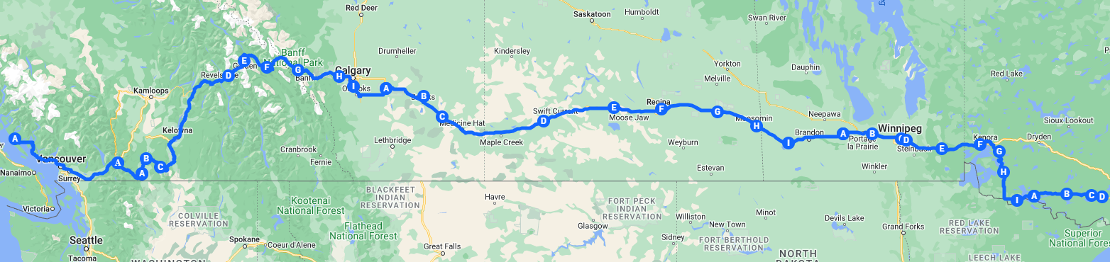
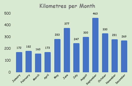
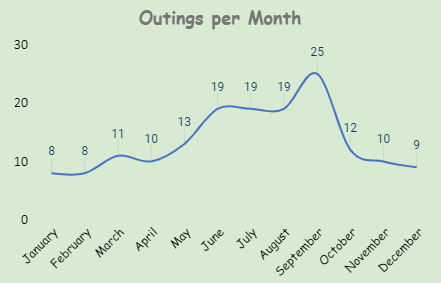
There you have it, 3,236 kilometres of club paddling in 2023. What a collective effort! It has been a wonderful trip with all of you, thank you. Some remarkably beautiful places along the way and I hope it held your interest. As a club achievement, everyone should be very proud. Working hard on our technique and stamina while at the same time making it fun. A combo that is not all that easily achieved. Go on, give yourself a pat on the back. Some stats: (remember, we measure by hulls in the water)
  Happy Paddling.
So here we are, 3,210 kilometres from home with one week left to go. By land we are still traveling in the Rainy River District in Northwestern Ontario. Along the way we went by Atikokan, population 2,642, which is one of the main entry points into Quetico Provincial Park and promotes itself as the "Canoeing Capital of Canada". Atikokan was originally established as a Divisional Point for the Canadian Northern Railway. The name Atikokan is believed to be derived from the Aboriginal language Ojibwa-Chippewa meaning “caribou bones” or “caribou crossing”; the town site was once the wintering ground for herds of caribou – many of them died here. Numerous rock paintings and lake names attest to the First Nations legacy of the Atikokan-Quetico area, an area blessed by Queticom, the Ojibwa Spirit of Unusual Beauty. Imagine a place with over 1 million acres of park land filled with unexplored waterways. Where there over 2000 back country campsites are only accessible by canoe, in more than 600 lakes. This is Quetico Provincial Park. Just south of Highway 71 between Fort Frances and Thunder Bay, along the northern border of Minnesota lies this merging of three eco-systems within the arctic watershed. Once known as the “Voyageurs Highway” in days of history gone by, it is now considered to be the canoeing capital of Canada. And access by water is the best way to really experience the park. https://en.wikipedia.org/wiki/Atikokan https://visitatikokan.com/ourstory/our-history/ https://visitatikokan.com/canoeing-capital-canada/ 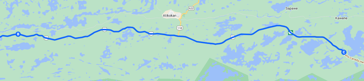 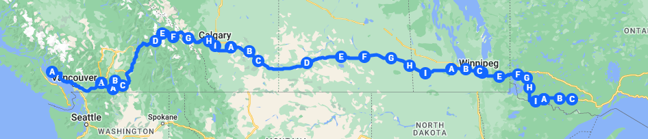 And by sea, we’ve certainly seen our share of shoreline – we end the week near Punta Blanca. The water temperature is 19.8c and the air is pretty much the same. Wind is approximately 30 kph with waves of 1.4 metres. Surfs up. A little land excursion is the Coastal Route Puna Blanca to Santa Rosaliita, it’s 57.8 miles and takes about 4 hours to drive. This trail, accessible from the Chapala Intermittent Route, is a relatively easy but remote path that guides you past Punta Blanca, leading all the way to a paved road less than a mile away from the breathtaking coastal town of Santa Rosaliita. While the trail is considered easy, it's important to remain cautious as any mistake in this isolated area could result in a challenging situation. There are a few minor obstacles, such as deep rain ruts that require careful navigation and a couple of steep rocky hills. However, local residents often traverse this route without the need for a 4WD vehicle. As you progress along the 50-mile trail, you may encounter a few other vehicles. Unfortunately, the mostly smooth and enjoyable surface gives way to a bumpy washboard road during the final 10-15 miles. Despite this, the route offers numerous campsites and provides access to several surf breaks of the Seven Sisters, making it a worthwhile addition to your itinerary. Although this trail is not difficult the Northern section is isolated and does not see much travel. Along the way, you will see many destroyed tires that make for a good reminder to be vigilant. Be prepared for self-recovery, and do not travel alone if possible. It is also important to have some sort of satellite communication for an emergency since there are no cellular signals. Also, beware that the estuaries that this route passes through are not passable in December and possibly some shoulder months due to higher tides so always check these areas before passing. These areas are so deep that during high tides some are actually fished in these months. There are alternate routes around the lowlands but this may not be a good route in early winter. The nearest advertised fuel is El Rosario or Jesus Maria. Santa Rosaliita does normally have Gasoline (but not Diesel) if you inquire at the tienda next to the Pacifico Hotel. https://www.surf-forecast.com/breaks/Punta-Blanca_1/forecasts/latest/six_day https://www.onxmaps.com/offroad/trails/mx/baja-california/coastal-route-punta-blanca-to-santa-rosaliita 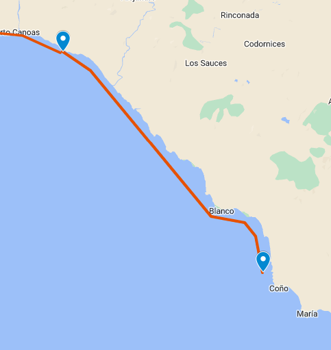  Week 50. Wow. 3,149 kilometres, double-wow. We end our day not far from Flanders Ontario, there is not much but forest and water between here and where we started the week. Having said that, a bit of sidetrack took us to White Otter Castle. White Otter Castle is an elaborate 3-storey log house built on the shore of White Otter Lake, by hermit, trapper, and fisher James Alexander "Jimmy" McOuat It is an example of typical log house construction at the turn of the 19th and 20th century, but remarkable "because of the uniqueness or ingenuity of the methods by which [it] came into existence. The "Castle" is a sturdy log house which stands 3 storys tall (8.8 metres, 29 ft), with a square tower extending up an additional floor (12 metres, 41 ft). The main part of the building measures 7.3 by 8.5 metres (24 by 28 ft), while an attached kitchen area adds a further 4.3 by 6.1 metres (14 by 20 ft) to the floorplan. It has 26 windows. McOuat built his "castle" single-handedly beginning in 1903 when he was 51 and finally completing it in 1915. He felled and cut all of the red pine logs himself, which were between 30 and 40 metres (98 and 131 ft) in length and 50 centimetres (20 in) in diameter. He hoisted the finished, dovetailed beams (some of them weighing as much as 730 kilograms or 1,600 pounds) into place by means of simple block and tackle. As a young boy, Jimmy threw a turnip at an elderly neighbour who cursed at him and said "You'll amount to nothing and die in a shack." Years later, in his forties and farming near Rainy River, he invested all that he had in a gold mine on the Upper Manitou. He lost everything, including his land. McOuat turned to trapping to earn a living and found himself on White Otter Lake, living in a rough trapper's shack. He became obsessed with what the old man said to him. Visitors to the cabin who met McOuat often commented that he would say "What do you think of my home - you'd never call that a shack, would you? McOuat is assumed to have drowned while netting fish in 1918. https://en.wikipedia.org/wiki/White_Otter_Castle 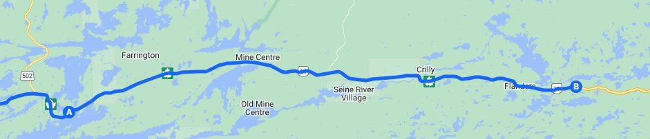  And by sea, well, we’re just further along. Some small fishing villages, some hardcore surfers and us. But, did you know,
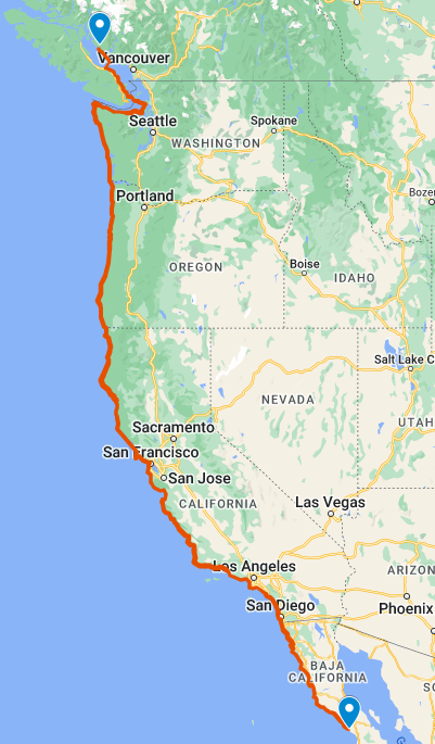
https://www.thoughtco.com/geography-of-baja-california-1435214 https://www.britannica.com/place/Baja-California-peninsula-Mexico https://www.history.com/topics/latin-america/baja-california 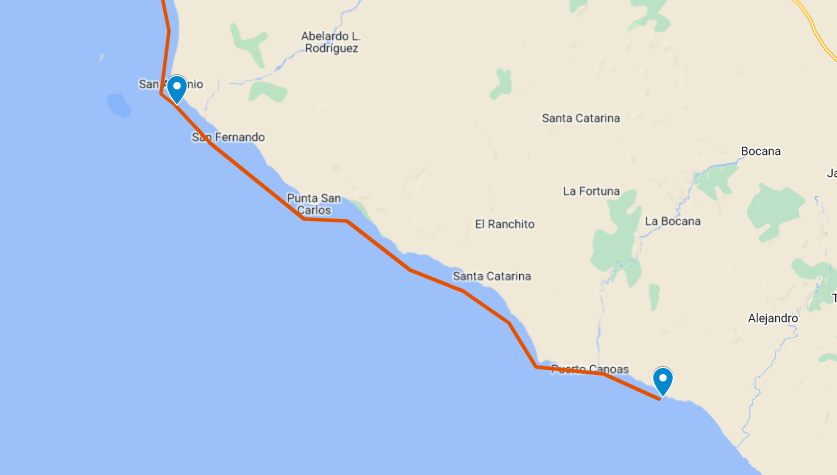 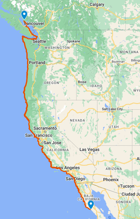 Well, here we are 3,071 kilometres from home. Part of this week’s journey has been on the Fort Frances Noden Causeway which officially opened on June 28, 1965. Prior to the causeway residents of Fort Frances and the surrounding area would have to travel up to Kenora and then east in order to reach Thunder Bay and beyond. With the causeway, this eight hour drive turned into three and a half. The causeway had the added benefit of opening road transportation for kids to go to school in Fort Frances. In the years before, the children living east of Fort Frances, were taught out of railcars (there was an existing rail line long before the causeway) that would come into the small centers and communities. Directly across the Rainy River from Fort Frances is International Falls, Minnesota, the two cities are connected by the Fort Frances – International Falls International Bridge. International Falls is nicknamed the "Icebox of the Nation,” with an average of 109.4 days per year with a high temperature below 32 °F (0 °C). January averages 5.0 °F (−15.0 °C), and lows reach 0 °F (−18 °C) on an average of 57.2 nights annually. Highs only reach the freezing point or above an average of 16.7 days in the months of December, January, and February, and the temperature often stays below freezing for weeks at a time during the winter. In the winter of 1978 to 1979, the temperature stayed below freezing for 101 days, from November 17 to February 25. Seasonal snowfall averages 73.0 in (185 cm); due to the cold typically preventing significant melting for much of the winter, snow depths of 5 in (13 cm) or more are seen on a majority of days from December through March. International Falls has long promoted itself as the "Icebox of the Nation"; however, the trademark for the slogan has been challenged on several occasions by the small town of Fraser, Colorado. Officials from Fraser claimed usage since 1956, International Falls since 1948. The two towns came to an agreement in 1986, when International Falls paid Fraser $2,000 to relinquish its "official" claim. However, in 1996, International Falls inadvertently failed to renew its federal trademark, although it had kept its state trademark up to date. Fraser then filed to gain the federal trademark. International Falls submitted photographic proof that its 1955 Pee Wee hockey team traveled to Boston, Massachusetts with the slogan. After several years of legal battles, the United States Patent and Trademark Office officially registered the slogan with International Falls on January 29, 2008, Registration Number 3375139. Only a few days after announcing its success in the trademark battle, International Falls had a daily record low temperature of −40 °F (−40 °C), beating a previous record of −37 °F (−38.3 °C) in 1967. https://en.wikipedia.org/wiki/International_Falls,_Minnesota  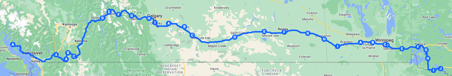 And by sea we’ve come to Punta San Antonio, which is kinda in the middle of no where. One surfing guide describes it as the following. Punta San Antonio is a rocky point reef break. Punta San Antonio breaks are super hard not only to find but to get to. Punta San Antonio is so hard to find that I can't even begin to tell you how to find them, but if you have a 4-wheel drive and are an adventurous person, Punta San Antonio has some great surf. As for the rest of the time, I won’t say we canoed by nothingness because there is always something, what I will say is we saw a lot of coastline and not much else. https://www.mexbound.com/punta-san-antonio/ 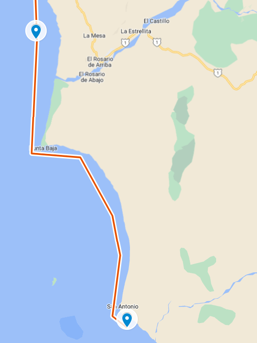 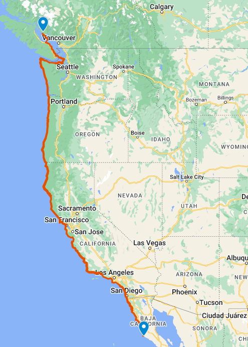 With just four more weeks to go we are about to blow by our goal by 1,000 km, we are now at 3,024 and just outside of Fort Frances – population 7,466. In 1817, following the War of 1812 and the redefinition of borders between Canada and the United States, the Hudson's Bay Company (HBC) built a fort here. In 1830 HBC Chief Factor John Dugald Cameron named the fur trading post after Frances Ramsay Simpson, the 18-year-old daughter of a London merchant, who had married earlier that year in London, to George Simpson, Governor of the Hudson's Bay Company, who would visit the fort many times. In 1841 she became Lady Simpson after George Simpson was knighted, and she died in 1853 at Lachine, Quebec. Along the way we went through Emo, which is located along the banks of Rainy River, directly north of the state of Minnesota. Emo is a scenic stop on the "MOM's Way" (Manitoba-Ontario-Minnesota) route. Emo is also home to the Norlund Chapel, one of the smallest churches in the world. Built by two local men in 1973, the chapel is open as a house of prayer for all but measuring just 8' x 10' can only hold eight people at a time. The chapel's steeple was salvaged from a church fire in 1971 and has a six-foot high iron cross forged by a local blacksmith in 1935. It’s the number one TripAdvisor think to see in Emo. Not far from Emo, a white sucker weighing 6lb 8oz was caught on the Rainy River which stands as the International Game Fish Association all tackle world record. https://en.wikipedia.org/wiki/Fort_Frances https://visitsunsetcountry.com/emo-ontario-canada https://en.wikipedia.org/wiki/Rainy_River_(Minnesota%E2%80%93Ontario) 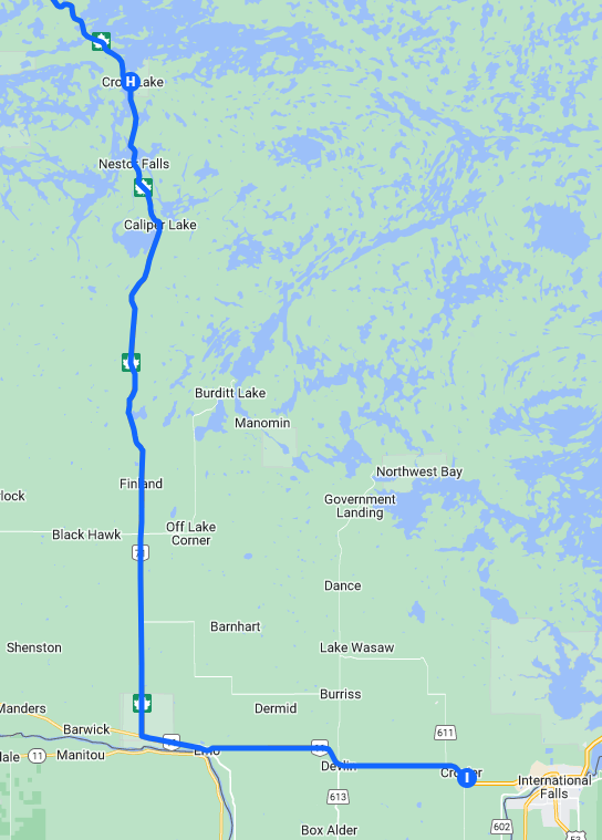 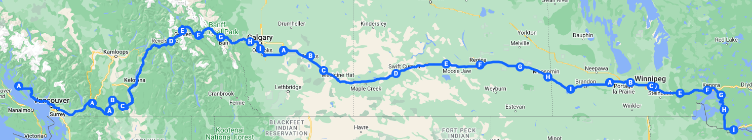 And by sea we’ve come to El Rosario de Arriba, home to 1,704 inhabitants. The town is one of many locations in Baja California visited by bird watchers, due to bird migration patterns, the Aplopappus vernicosus is a Mexican species of shrub in the family Asteraceae, that has been found almost exclusively in this town. The town is located on Mexican Federal Highway 1 and also a stop on the Baja 1000 racing event. I didn’t know this, we’ve been traveling through volcano country, in particular the San Quintin Volcanic Field. The San Quintín Volcanic Field is a collection of ten or eleven volcanic cinder cones situated along the Pacific coast of the Baja California peninsula. The field formed by repeated eruptions beginning in the Pleistocene and ending about 3000 years ago. We did get to spend some time at the Punta Mazo Natural Reserve. Located in San Quintín, the Punta Mazo Nature Reserve is a sanctuary of coastal bushes, marshes and pristine beaches. This paradisiacal corner is a paradise for lovers of hiking and camping, as well as an ideal refuge for bird watchers. Cataloged as a Ramsar area, it is a vital area for the conservation of migratory birds. Nestled in the center of the bay, this reserve is home to an extinct volcano, an interpretive trail, and a rich diversity of animal and plant species. Since its federal certification in 2017, Monte Ceniza has been an example of successful conservation and is home to unique species of plants and animals With free access and flexible hours, the reserve is a paradise for hikers, nature photographers and those looking to connect with their surroundings. If you're looking for a thrill, here you'll find activities ranging from stargazing, hiking and mountain biking to bird watching and rare species such as the kangaroo rat, which was thought to be extinct. https://en.wikipedia.org/wiki/El_Rosario,_Baja_California https://en.wikipedia.org/wiki/San_Quint%C3%ADn_Volcanic_Field https://travel.tepatepec.mx/san-quintin-explora-reservas-naturales-y-humedales-en-bc/ 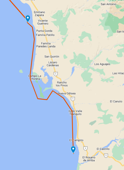 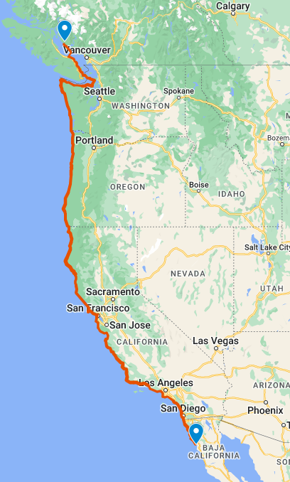 2, 930 kilometres! As we get ready for the final days of November, we find ourselves in Crow Lake Ontario. Back Kenora way we could have taken highway 17 east through Dryden and on to Shabaqua Corners but we’ve headed south to International Falls and from there to Shabaqua Corners. Having done both routes I’m not sure one is better than the other but hey, how often do you get to see Minnesota. Mostly what we’ve seen are lakes, trees, fishing camps and resorts. We did get to Sioux Narrows where in the mid-18th century, an Ojibwa-Cree alliance is said to have defeated an invading party of Sioux at a narrows here on the lake. Sioux Narrows is named in recognition of that event. We are still in Lake of the Wood country which in Ojibwe: Pikwedina Sagainan means '"inland lake of the sand hills"'. Lake of the Woods is over 110 km long and wide, containing more than 14,552 islands and 105,000 km of shoreline. You could stay on a different island each night of the year for over 39 years. Lake of the Woods is home to walleye, northern pike, perch, sauger, crappie, panfish, smallmouth bass, largemouth bass, lake trout, lake sturgeon, and muskellunge. Lake of the Woods is nicknamed the "Walleye capital of the world". The lake is the host of year-round fishing, with ice fishing being a popular recreation activity on the lake. (Having been ice fishing myself I’m going to say, yah, once was enough.) While Lake of the Woods is huge and considerably deep in certain areas, the lake freezes completely over every winter. The average ice thickness is between 25 and 30 inches. The fact the entire lake freezes to the thickness it does, you basically end up with over 1,700 square miles of landscape that wasn’t there during the warmer months. Locals take full advantage of this and create literal ice roads to traverse the lake. https://en.wikipedia.org/wiki/Lake_of_the_Woods https://northernontario.travel/fishing/10-facts-about-lake-woods https://riverbendresort.com/5-facts-about-lake-of-the-woods/ 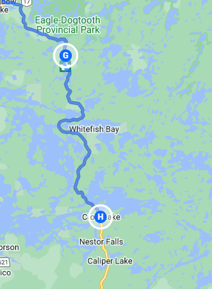 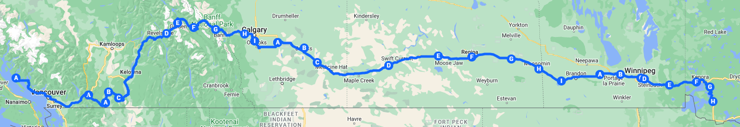 And by sea we come to the town of Vincente Guerrero which is named after the man with the same name. Vicente Ramón Guerrero, (baptized August 10, 1782 – February 14, 1831) was a Mexican soldier and statesman who became the nation's second president. He was one of the leading generals who fought against Spain during the Mexican War of Independence. He is the first and so far only Mexican President of African descent and the first black president in North America. Guerrero was president but it was not based on the popular vote. One scholar sums up Guerrero's situation, "Guerrero owed the presidency to a mutiny and a failure of will on the part of [President] Guadalupe Victoria...Guerrero was to rule as president with only a thin layer of support. A key achievement of his presidency was the total abolition of slavery in Mexico. Guerrero called for public schools, land title reforms, industry and trade development, and other programs of a liberal nature. As president, Guerrero championed the causes of the racially oppressed and economically oppressed. But it wasn’t too last, Guerrero was deposed in a rebellion under Vice-President Anastasio Bustamante that began on 4 December 1829. Guerrero left the capital to fight in the south, but was deposed by the Mexico City garrison in his absence on 17 December 1829. Guerrero had returned to the region of southern Mexico where he had fought during the war of independence. Open warfare followed, he was eventually captured and executed. We also went by Cuatro Casas home of the Cuatro Casas Hostel which back in 2018 was identified by RedBull (the energy drink company) as one of the 8 skate (as in skate board) friendly hotels and hostels on the need to visit list. Cuatro Casas Hostel lies on the beach overlooking a perfect Baja California vista, far from the biggest nearby cities of Tijuana and Ensenada. You'll find the hostel at the end of a dirt road once you see the ocean. Make sure to bring your own food and drinks, as there's no restaurant around, but you can use the kitchen and there's a grill sitting right on the pool deck – how does that sound? The pool (which is what you skate in) is a properly tight backyard replica complete with tiles and deathbox. Tranny dogs, rejoice. (I don’t know what that means. I think I’ll stick to paddling.) https://en.wikipedia.org/wiki/Vicente_Guerrero https://www.redbull.com/int-en/8-skate-hotels-from-around-the-world 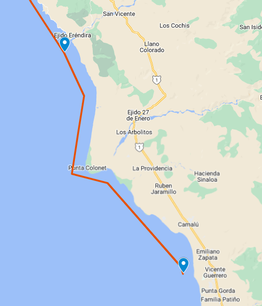 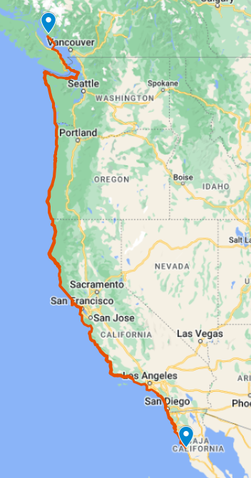 We’ve now paddled 2,859 kilometres – wow. We find ourselves just outside of Eagle-Dogtooth Provicial Park, the landscape is a transition between the Great Lakes-St. Lawrence and boreal forest regions, with regionally significant moraines, wetlands, and pine forest ecosystems. Several of the lakes within the park are part of the Experimental Lakes Area, which is a controlled area for conducting scientific experiments in lakes. Experimental Lakes Area (ELA) is an internationally unique research station encompassing 58 formerly pristine freshwater lakes in Kenora District Ontario, Canada. In response to the International Joint Commission (IJC)'s 1965 recommendations related to transboundary pollution, the federal and provincial governments set aside these lakes to study water pollution. During the 1970s and 1980s, David Schindler, who was at that time 'Canada's leading ecologist', conducted a series of innovative, landmark large-scale experiments in ELA on eutrophication that led to the banning of phosphates in detergents. In an unexpected and controversial move that was widely condemned by the scientific community in 2012 the ELA was de-funded by the Canadian Federal Government. The facility is now managed and operated by the International Institute for Sustainable Development (IISD) and has a mandate to investigate the aquatic effects of a wide variety of stresses on lakes and their catchments. IISD-ELA used the whole ecosystem approach and makes long-term, whole-lake investigations of freshwater focusing on eutrophication (The process by which an entire body of water, or parts of it, becomes progressively enriched with minerals and nutrients, particularly nitrogen and phosphorus. A common visible effect of eutrophication is algal blooms). https://en.wikipedia.org/wiki/Eagle-Dogtooth_Provincial_Park https://en.wikipedia.org/wiki/Experimental_Lakes_Area https://en.wikipedia.org/wiki/Eutrophication 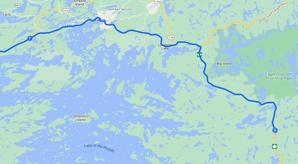 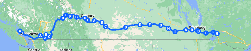 And by sea we end the day at Ejiro Erendira, population 1,461 with another 1,500 seasonal residents. Nearby there is an area that had been used by pre-historic peoples that gathered seasonally here to collect shellfish such as clams, sea snails, mussels and other. They left a layer of shells over eight meters thick that Canadian archeologists have dated back over 10,000 years. So far, we’ve been paddling along the state of Baja California (Lower California) which is officially called Estado Libre y Soberano de Baja California (Free and Sovereign State of Baja California). It is the northernmost and westernmost of the 32 federal entities of Mexico. Before becoming a state in 1952, the area was known as the North Territory of Baja California. https://en.wikipedia.org/wiki/Ejido_Er%C3%A9ndira https://en.wikipedia.org/wiki/Baja_California 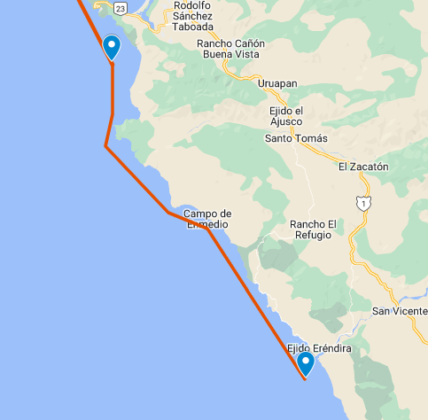 Welcome to Ontario and Lake of the Wood. 2,800 kilometres done. We end our day just short of Kenora, once known as Rat Portage. The history of the name extends beyond the time of French settlers arriving in the region. The name Rat Portage had its origin in the Ojibwa name Waszush Onigum, which roughly translated, means portage to the country of the muskrats. A shortened and somewhat corrupted version, Rat Portage, was adopted by the Hudson’s Bay Company in naming their post, then located on Old Fort Island on the Winnipeg River. When the post was moved to the mainland and a town grew up around it, the name Rat Portage was assumed by the community. The town of Rat Portage was renamed in 1905 by using the first two letters of itself and the neighbouring towns of Keewatin and Norman to form the present-day City of Kenora. Ke(ewatin), No(rman), Ra(t Portage). Now here’s an interesting thing, The Stanley Cup was won by the Kenora Thistles hockey team in 1907. The team featured such Hall of Famers as Billy McGimsie, Tommy Phillips, and Art Ross, for whom the Art Ross Trophy is named. Kenora is the smallest town to have won a major North American sports title. A little time in and around Lake of the Woods was great, the 36th largest lake in the world by area, occupies parts of Manitoba, Ontario and Minnesota. The lake separates a small land area of Minnesota from the rest of the US. Known as the Northwest Angle, it can only be reached by crossing the lake or traveling through Canada. So very much the same as Point Roberts in Washington State. The Northwest Angle is the northernmost part of the contiguous United States. https://en.wikipedia.org/wiki/Kenora https://en.wikipedia.org/wiki/Lake_of_the_Woods 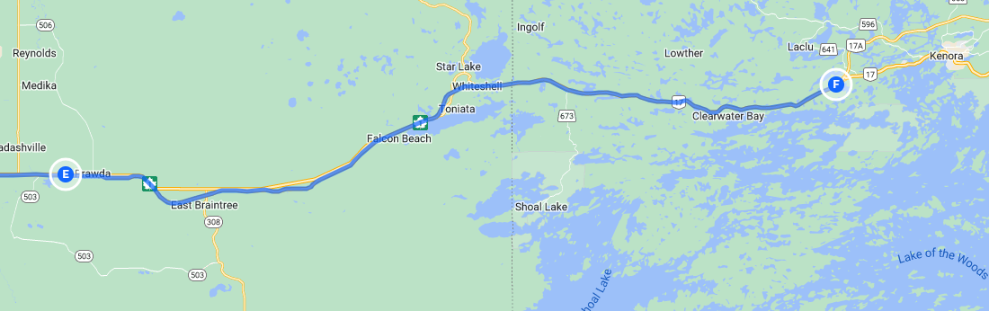 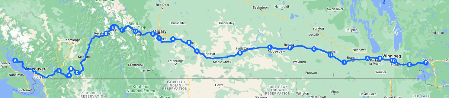 Any by sea we continue along the coast of Mexico ending our day near Ensenada. Off to the west we can see the Todos Santos Islands which are best known for being a place for surfing . It is sometimes referred to as a single island, but Todos Santos is actually two islands: Isla Todos Santos Norte (smaller, to the north), and Isla Todos Santos Sur (larger, to the south). There are no facilities on the islands except two crumbling lighthouses and a fish field. The smaller island's waves are some of the largest waves on the American continent. Due to their great natural importance and level of endemism, as of 2016, by presidential decree, the two islands of this group, as well as the surrounding sea, are part of the Biosphere Reserve "Pacific Islands of the Baja California Peninsula”, which in turn protects other neighboring islands. And just for the record, the November daily average high temperature at Ensenada is 22.3. Think about that next Tuesday while pulling on the neoprene. https://es.wikipedia.org/wiki/Todos_Santos_(Baja_California) 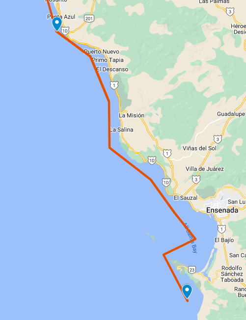 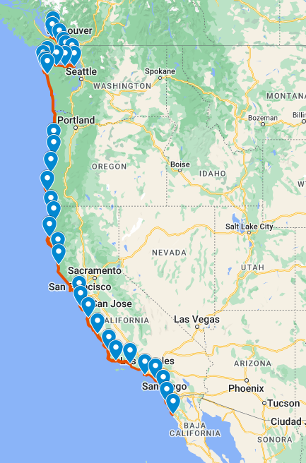 Finishing off week 44 has us at 2,718 kilometres. It was great fun having the Fun & Fitness (rec) crew paddling along with us. We’ll miss them. On the road we end our week just outside of Prawda Manitoba, population 200. The community's name comes from the Polish word prawda, which means 'truth' and is named after the town of the same name in Poland. The area was settled by Ukrainian, Polish, and Russian settlers starting about 1907. The big news this week is we have gone more than half way across Canada. No trip along this stretch of the Trans Canada is complete without a stop at the Center of Canada Park 96° 48’ 35’’. The Reginal Municipality of Taché sits on the longitudinal centre of Canada. Located at the side of the TransCanada Highway, this nexus is crossed by tens of thousands of travellers each year. Taché seized the opportunity to mark the occasion and, in 2017, the municipality opened the Centre of Canada Park, a tourist destination featuring walkways and interpretive panels. It should be noted however that this is the longitudinal center only, the longitude and latitude center is claimed by the people of Baker Lake, Nunavut. For the record the geographic center of B.C. is near Vanderhoof. Well, how can you travel this part of the Trans Canada and not stop at the Giant Stump, which is not an actual stump. The giant stump was built by the province in the 1960s as a pedestal for a Smokey the Bear statue, along the proposed route for the Trans-Canada Highway east of Winnipeg, which was being twinned at the time. The forests there had been destroyed by a raging fire in 1955, and the replanted trees were still mere saplings. Two summer hires built the giant stump, which is more than three metres across and about stomach-high on an average adult. It’s made of concrete and perhaps some fibreglass composite for its exterior bark. But then engineers changed their plans and built the Trans-Canada about 100 metres farther north. The province abandoned its plans to erect Smokey the Bear and just left the stump in the bush. There’s an old logging trail to the giant stump. People have been visiting the stump for picnics, to show visitors, or just as a meeting place for over half a century. It’s also a popular geocache site. https://en.wikipedia.org/wiki/Prawda,_Manitoba https://www.winnipegfreepress.com/breakingnews/2015/09/02/the-old-stumping-grounds https://www.mhs.mb.ca/docs/sites/smokeystreestump.shtml https://www.cdem.com/en/communities/tache/ 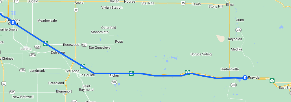 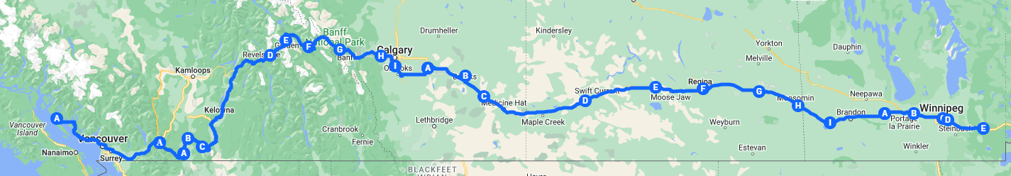 And by sea, pasaporte por favor. Welcome to Mexico. A stop in Tijuana for a picture with the zonkeys and some salad. Whoever said zebras don't belong in Mexico must've never met the fashionable donkeys strutting their stripes along Avenida Revolución: Tijuana's popular "zonkeys" are donkeys painted with zebra stripes, delighting tourists with an adventurous photo op and a thrilling twist to their vacation memories. Source => theculturetrip.com When Caesar met Prohibition, it wasn't a Shakespearean tragedy, but a mouthwatering Mexican fiesta: Tijuana became America's watering hole during the dry days of Prohibition, with thirsty folks crossing the border to partake in booze and gambling, and Caesar's Restaurant on Avenida Revolución blended right in, creating the now-iconic Caesar salad and elevating it to a Mexican culinary classic. Source => cbs8.com And we can be grateful we did an ocean-based border crossing. Looking for a busy commute? Try squeezing through the world's busiest border crossing: The San Ysidro border point in Tijuana boasts more than 106 million individual crossings and 48 million cars and trucks annually, making it not only the liveliest land border point between the United States and Mexico but also the ultimate hotspot for quick Tijuana-San Diego trips. Source => sandiego.com https://funfactfiesta.com/travel-and-geography/cities-and-towns/tijuana/ 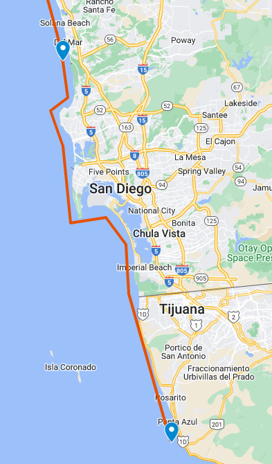  Still going strong; 2,637 behind us. We end our road travels for the day at Deacons Corner, which is named in honour of Mayor T. R. Deacon. Mr. Deacon was mayor of Winnipeg from 1913 – 1914 and it was during his term that the construction of the Greater Winnipeg Water District Railway and Aqueduct commenced. Back in 1906 Winnipeg City Council realized that their water supply would not be enough to support the growing city. The first recommendation was to tap into the Winnipeg River for future water supply but this was eventually turned down due to financial conditions. In 1912, upon a request of the City of Winnipeg, the Public Utilities Commission made a study of the water supply for Winnipeg. Its recommendation was that Shoal Lake, part of the Lake of the Woods, would be a logical water source and that other municipalities might join in this project. On 7 April 1913 the Winnipeg City Council appointed the Board of Consulting Engineers to investigate and submit a report on the best means of getting the water supply from Shoal Lake, together with an estimate of costs. On 20 August 1913 the report of the Board of Consulting Engineers was received. It showed that Shoal Lake could supply 85,000,000 imperial gallons of water daily, an ample amount to satisfy the needs of an 850,000 population. During the construction, stop-over points were named by station numbers. Later on, stations were designated as Mile so-and-so. In time with the establishment of settlements, names were given to stations. Thus, the first station from Winnipeg was named Deacon. A stop at The Forks National Historic Site is pretty much a must do when passing thru Winnipeg. The Forks was designated a National Historic Site of Canada in 1974. It is designated because, strategically located at the juncture of the Red and Assiniboine rivers, this spot has witnessed many of the key events of western Canadian history. The heritage value of The Forks lies in the millennia of human activity to which its cultural landscape bears witness. Its heritage value is embodied in its geographical location, the evidence of past activity and the commemoration of past activity it contains, and its strategic impact upon the surrounding development. And where would we be without Winnipeg’s Paul Faraci – he invented Pizza Pops back in 1964 https://www.mhs.mb.ca/docs/pageant/24/winnipegaqueduct.shtml https://www.pc.gc.ca/apps/dfhd/page_nhs_eng.aspx?id=151#:~:text=The%20Forks%20National%20Historic%20Site%20of%20Canada%20is,on%20the%20west%20bank%20of%20the%20Red%20River. https://www.travelmanitoba.com/blog/43-fun-facts-about-manitoba-that-will-blow-your-mind/ 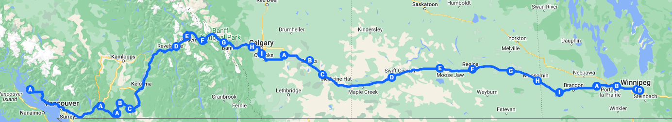 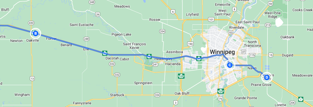 And by sea we’ve come to Torrey Pines State National Reserve. Torrey Pines State Natural Reserve is a wilderness island in an urban sea. This fragile environment is the home of the nation's rarest pine tree - Pinus torreyana. Once this tree covered a larger area. It now grows only here and on Santa Rosa Island off the coast near Santa Barbara. The park preserves not only the trees, but also one of the last salt marshes and waterfowl refuges in Southern California. The reserve features high broken cliffs and deep ravines on headlands overlooking the ocean. Hikers can follow trails through stands of wind-sculpted pines. For the young, or young at heart, and since we were passing right by, a stop at LegoLand. Yup, Lego has its own adventure theme park, actually there are something like 11 of them spread around the world with more under construction. The first one opened in Denmark in 1968, it is built next to the original Lego factory. Windsor England got the next one in 1996 and it’s spread from there. I’d say pretty much the direct opposite of the Torrey Pines park. Another stop along the way was the Del Mar Fairgrounds where, in 1936, the Del Mar Racetrack was built by the Thoroughbred Club with founding member Bing Crosby providing leadership. On August 12, 1938, the Del Mar Thoroughbred Club hosted a $25,000 winner-take-all match race between Charles S. Howard's Seabiscuit and the Binglin Stable's colt, Ligaroti. In an era when horse racing ranked second in popularity with Americans to Major League Baseball, the match race was the first nationwide broadcast of a Thoroughbred race by NBC radio. In the race, Seabiscuit was ridden by jockey George Woolf and Ligaroti by Noel Richardson. In front of a record crowd that helped make Del Mar race track a success, Seabiscuit won by a nose. https://www.parks.ca.gov/?page_id=657 https://en.wikipedia.org/wiki/Legoland https://en.wikipedia.org/wiki/Del_Mar_Fairgrounds#Racetrack San Diego is just around the corner… 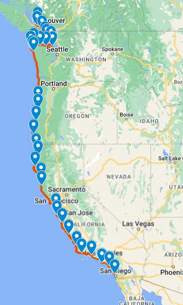 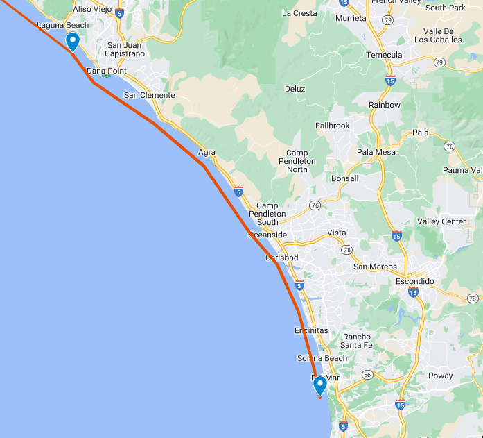 |
 RSS Feed
